
AUSTRALIA


Kakadu National Park
NEW ZEALAND


Aoraki/Mount Cook National Park
Daintree National Park
The Daintree National Park is
located in Far North Queensland, 100km northwest of Carins. It was founded in
1981 and was granted listing in the Wet Tropics World Heritage List in 1988. It
is accessible by car and most trips leave from Cairns or Port Douglas.

Mossman Gorge section
The main entrance to the park is
at Mossman Gorge, where visitors can see the very best rainforest. Here there
are visitor tracks that offer views of beautiful fauna and flora, as well as a
large river that is a popular swimming hole.

Cape Tribulation section
Originally the cape belonged to
the Cape Tribulation National Park, however was merged into the Daintree
National Park in 1983. This section covers 17,000 hectares along a narrow
coastal strip of long sandy beaches. It is one of the most biologically diverse
areas in the world.

Kosciuszko National Park
The Kosciuszko National Park is
located in New South Wales, 354 km southwest of Sydney. The park covers 6,900
square kilometers and is home to mainland Australia’s highest peak – Mount
Kosciuszko. Its borders contain a mix of mountains and wilderness, making it
popular with recreational skiers and bushwalkers.

The higher regions of the park
experience an alpine climate, an unusual occurrence on mainland Australia. The
mountains are typically covered by metre-deep snow for up to four months of the
year, and the park attracts many skiers to its ski stations such as Perisher
and Thredbo. However it is also popular in the summer, and many people use the
Australian Alps Walking Track. Many rare or threatened plant and animal species
reside within the boundaries of the park, for example the Corroboree frog, one
of Australia’s most threatened species.

Uluru and Kata Tjuta National Park
 |
| Uluru and Kata Tjuta, Northern Territory |
Uluru
Uluru, or
Ayers Rock, is a large sandstone
rock formation in the southern part of the Northern Territory,
central Australia. It stands at 3.6km long and rises a
towering 348m from the surrounding sandy scrubland (867m above sea level) and
it is even believed that two-thirds of the rock lies beneath the sand.
Kata
Tjuta and
Uluru are the two major features of the Uluṟu-Kata Tjuṯa
National Park. Uluru is sacred to the Anangu, the Aboriginal
people of the area. The area around the formation is home to a
plethora of springs, waterholes,
rock caves and ancient
paintings. Uluru is listed as a World Heritage Site
and if not for the wonder of this incredible natural occurrence, a trip to
Uluru is worth it for the cultural experience.
 |
| Uluru, Northern Territory |
The landscape of Uluru changes dramatically with the
shifting light and seasons. If your first sight of Uluru is during the
afternoon, it appears as an ochre-brown colour, scored and pitted by dark
shadows. As the sun sets, it illuminates the rock in burnished orange, then a
series of deeper and darker reds before it fades into charcoal.
Kata Tjuta
Kata Tjuta,
also called Mount Olga or The Olgas, lies 25 km (16 mi) west
of Uluru. Kata Tjuta means 'many heads' and is of great tjukurpa significance,
so climbing on the domed rocks is not permitted however, special viewing areas
with road access and parking have been constructed to give tourists the best
views of both sites at dawn and dusk.
 |
| Kata Tjuta aerial view, Northern Territory |
The
36 domes that make up Kata Tjuta cover an area of 21.68 km2
(8.37 sq mi), are composed of conglomerate,
a sedimentary
rock consisting of cobbles and boulders of varying rock types
including granite
and basalt, cemented by a
matrix of sandstone.
 |
| Kata Tjuta, Northern Territory |
The best way to view Kata Tjuta is to take the Valley of
the Winds walking track, a 7.4km loop trail (two to four hours) that traverses
varying desert terrain and yields wonderful views of surreal boulders. Like
Uluru, the Olgas are at their glorious, blood-red best at sunset.
Kakadu National Park
World
Heritage Listed Kakadu National Park is Australia’s
largest national park and home
to a variety of habitats and wildlife, including saltwater crocodiles.
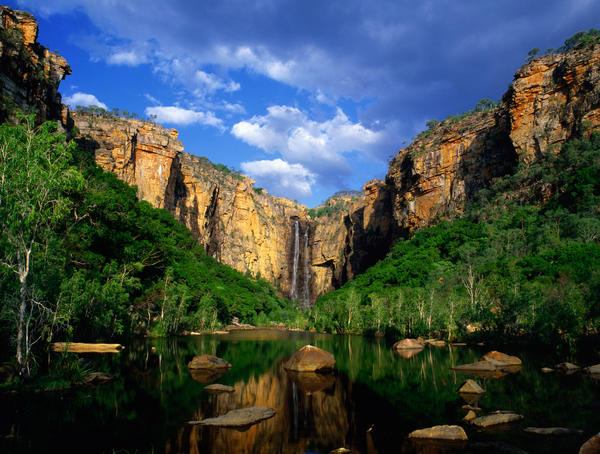 |
| Jim Jim Falls, Kakadu National Park |
Kakadu
provides extraordinary natural and human histories witch will defy anything you
have read. Even old-hand nature buffs will find for the first time seed pods,
insects and animals unique to the area.
 |
| Red Lily Billabong, Kakadu National Park |
The 2000 million-year-old rocks tell
20, 000-year-old stories: of the existence of long-extinct giant kangaroos and
thylacines. There are hundreds of square kilometres of park, so allow at least
three days to discover a smidgen.
 |
| Arnhem Highway, Kakadu |
Parks
Australia and the traditional owners, the Bininj in the north and Mungguy in
the south, who have lived in Kakadu for at least 50, 000 years. There are
several settlements in the park, and much of Kakadu is Aboriginal land, leased
to the government for its current use. About one-third of the park rangers are
Aboriginal people.
 |
| Yellow Water, Kakadu National Park |
Top places to visit:
- Jim Jim and Twin Falls
- Explore the wetlands at Yellow Waters
- Discover the amazing caves and artwork at Nourlangie Rock
- Day trip to Arnhem Land or Gunbalanya to visit Oenpelli
- Bubba Bubba wetland walk
- Take a cruise up the East Alligator River
- Gaze at Gunlom escarpment waterfall
- Visit Ubirr Gallery and Nardab lookout
 |
| Kambolgie Billabong, Kakadu National Park |
NEW ZEALAND
Abel Tasman National Park
The coastal Abel Tasman National
Park is New Zealand’s most visited national park. It is renowned for its golden
beaches, sculptured granite cliffs, unmodified estuaries and world-famous Abel
Tasman Coast Track. It has a mild climate and is a good place to visit at any
time of the year, however is particularly popular in summer. It is located at
the top of the South Island, and the nearest towns are Motueka and Takaka.


Natural highlights
The park is famous for its golden
sandy beaches, fascinating rocky outcrops, the estuaries and the offshore
islands. There are a number of forest birds that can be seen, such as tui and
bellbirds. All native wildlife, natural, cultural and historic features are
protected within the park.

Things to do
Walking – The Abel Tasman Coast
Track is 51kms long and suits most ages and levels of fitness. Most people can
walk it in 3-5 days with plenty of time to explore.
Sea kayaking and sailing – these
activities allow you to access some of the sheltered coves now available by the
walking track.


Facilities
There are eight huts in the park
that have bunks, tables, benches and heating. There are also numerous campsites
in the park with water supplies and toilets.
Aoraki/Mount Cook National Park
Aoraki/Mount
Cook (70,696 hectares) is New Zealand's great alpine park. It was
formally established as a national park in 1953 from reserves that
were established as early as 1887 to protect the area’s significant vegetation
and landscape.
 |
| Mount Cook, New Zealand |
Aoraki/Mount Cook is located in the central part of the South
Island, deep in the heart of the Southern Alps. Aoraki/Mount Cook village lies
within the park with Twizel the nearest town outside
It has
the highest mountains and the largest glaciers - of the 27 New
Zealand mountains over 3050m, 22 are in this park. Aoraki/Mount Cook village and all visitors to
the park are dwarfed by the immensity of the landscape that surrounds them. The
highest is the mighty Mt Cook, and at 3755m it’s the tallest peak in
Australasia. Known to Maori as Aoraki (Cloud Piercer), after an ancestral deity
in Maori mythology, the mountain was named after James Cook by Captain Stokes
of the survey ship HMS Acheron.
 |
| Mount Cook, New Zealand |
Top things to do:
- Go Heliskiing down Mount Cook
- Go fishing
- Trekking
- Take a boat tour on the glacier lakes